Pau-brasil


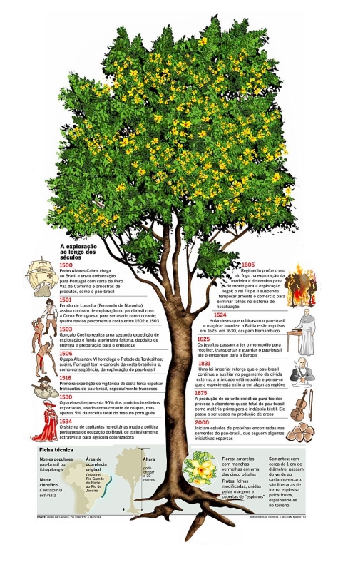
Acho que somos o único país do mundo a receber nome de planta. Legal isso 😀 Seria mais legal ainda se o pau-brasil não estivesse ameaçado…outro dia vi uma reportagem sobre isso. Dizia que o pau-brasil, além do corante, possui propriedades adstringentes, anti-inflamatórias e anti-cancerígenas (tanto sarcomas como carcinomas responderam bem a testes feitos em ratos de laboratório). Sem contar que é uma árvore linda, claro 😉


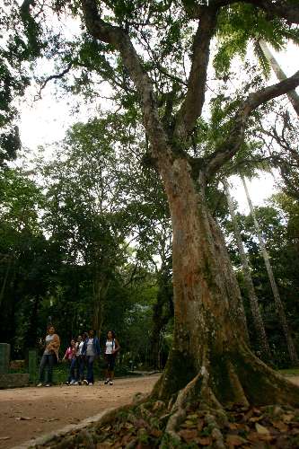
Uma das pesquisadoras dizia, ao final da reportagem: “Seria bom se as pessoas plantassem o pau-brasil…assim, deixaria de figurar na lista da quase extinção”. Tá. Aí eu, que adoro plantas, pergunto: onde achar?? Até hoje acho que vi apenas 2 árvores de pau-brasil, e em áreas de conservação. Onde acha semente ou muda de pau-brasil para plantar??? Se alguém souber, favor entrar em contato comigo…escreva aí embaixo.

Editado: ops, esqueçam! Acabei de pesquisar, tem aqui: http://www.projetopaubrasil.com.br/

Para comprar: 
Vendas por Sedex: 
mínimo 15 mudas – R$ 15,00 por unidade + custo do Sedex.
Pedidos em grande quantidade: 
entar em contato através do telefone ou e-mail abaixo (em virtude de redução de preço conforme a quantidade e ser preciso calcular o frete).
Sementes: Não fornecemos devido à curta vida das mesmas.

Entre em contato pelo atendimento@projetopaubrasil.com.br , pelo (21) 3521-6700 ou skype: projetopaubrasil.

Tem também nesse outro site: http://www.proecologia.com.br – F: (32) 32571142 • End: BR 040 km 792 São Pedro Juiz de Fora MG CEP 36039-080 – mas não diz quanto custa…talvez fique mais barato, pois o frete de Minas deveria, teoricamente, custar menos que o da Bahia.

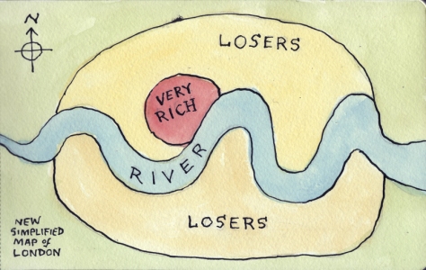
Simplified map of London


This map came from here. And so did the following comments:

  1. “I live in London and this map is fairly accurate. The Very Rich area would be Pimlico, maybe Notting Hill, Kensington and Chelsea, Westminster, the West End, Primrose Hill, maybe Hampstead. London has other wealthy areas but what differentiates these from those is that these areas have always been wealthy, rather than Johhny come lately areas that have been gentrified.”
  2. “General rules of thumb: in a city the wealthier neighborhoods tend to be upwind, upriver, and uphill. Occasionally extreme geographic constraints will override those rules. In the case of London, the Thames was horribly polluted and smelly in the first half of the 18th century (look up “The Great Stink”). My guess is that the “Very Rich” area would be the westernmost part of London in 1850, and that the “Losers” area west of there developed after the Thames was cleaned up. (I should line up some historical maps of London to the above map to see.)”
  3. “It just goes to show you. It takes a lot of losers to support a few rich folks.”
  4. “Have you seen the houses in Richmond or Hampstead? They don’t look like looser houses to me… There was actually an article in Time Out which mapped the London Boundary in relation to were the first Harvester eatery is located. So, were Harvester starts London stops. That is a clever way to show social divide within a city.”

Sistema Numérico dos Babilônicos


A civilização babilônia substituiu a civilização suméria por volta do ano 2000 a.C.

Os babilônicos eram um povo semita que invadiu a Mesopotâmia, derrotando os sumérios, estabelecendo sua capital na Babilônia.

As civilizações antigas da Mesopotâmia são comumente chamadas de babilônicas, apesar da cidade de Babilônia não ter sido o centro de cultura do vale Mesopotâmico.


Aos babilônios se deve a invenção do sistema posicional. Com apenas dois símbolos (um para a unidade e um para a dezena dezenas)podiam representar qualquer número, por maior que fosse, por repetição e mudança de posição. Este é o mesmo princípio de nosso sistema numeral.

Assim a numeração dos babilônios era escrita da seguinte forma:

A civilização babilônica substituir a suméria e a Acádia, e como se pode notar,  os babilônios herdaram idéias dos sumérios e dos acádios para formas o seu próprio sistema numérico.

Até então, nem o sistema numérico dos Sumérios e nem o dos acádios era posicional. Já o sistema criado pelos babilônios era um sistema posicional, o que se tornou uma grande realização. O estabelecimento da ordem posicional para os símbolos numéricos foi a maior realização matemática dos babilônios.

Embora o sistema babilônico fosse um sistema posicional de base 60, teve alguns vestígios do sistema de base 10 dentro dele. Isto porque os 59 números que compõem esse sistema são formados por um símbolo para a unidade e um para a dezena.

Cientistas descobrem um quarto exoplaneta potencialmente habitável


Uma equipe internacional de astrônomos anunciou nesta quinta-feira a descoberta de um novo exoplaneta potencialmente habitável, elevando para quatro o número de planetas situados fora de nosso sistema solar detectados pela comunidade científica.

“Este planeta rochoso é o novo e melhor candidato para manter água em estado líquido em sua superfície e pode abrigar vida tal qual nós a conhecemos”, explicou Guillem Anglada-Escudé, chefe da equipe que trabalha na Carnegie Institution for Science, em Washington.

Este planeta (GJ 667Cc) está em órbita em torno de uma estrela batizada de GJ 667C, situada a cerca de 22 anos-luz da Terra (um ano-luz equivale a 9.460 trilhões de quilômetros).

Ele contorna a sua estrela em 28 dias e tem uma massa mínima 4,5 vezes a da Terra. É também cerca de 50% mais pesado que o nosso planeta.

O planeta se encontra a uma distância de sua estrela em uma “zona habitável”, onde as temperaturas não são nem muito quentes nem muito frias, permitindo que a água permaneça em estado líquido.

Os pesquisadores também descobriram indícios que levam a crer que pelo menos um outro exoplaneta, talvez até três, estão em órbita na mesma estrela.

O manuscrito será publicado na internet no site arxiv.org/archive/astro-ph.

Os astrônomos utilizaram dados públicos do Observatório Europeu Austral (ESO) no Chile que analisaram de acordo com um novo método.

Eles incorporaram medidas efetuadas com os telescópios do Observatório Keck no Havaí

via Cientistas descobrem um quarto exoplaneta potencialmente habitável – 02/02/2012 – Ciência e Saúde – AFP.

Um, dois e muitos


Provavelmente os números 1 e 2 foram os primeiros a serem inventados. Levando em consideração que a mente humana é capaz de reconhecer rapidamente, dentre muitos objetos, uma quantidade de um ou de dois. Assim sendo, fica fácil imaginar que foram estes os primeiros algarismos a serem inventados.

Um
O número 1 tem o sentido do Eu, do pessoal, do inteiro e nas representações numérica aparecia como um traço vertical indicando o homem em posição ereta. O número 1 tem o sentido do masculino, levando em consideração a primeira criação de Deus ser do sexo masculino. Assim sendo, supomos que foi relativamente fácil e lógica a criação do sinal “1”, ou seja, do número 1 para representar a unidade.

Dois
O número 2 nos dá o sentido da existência do outro, do feminino na dualidade masculino/feminino. O número 2 também é símbolo de oposição, de ambigüidade, de divisão, de rivalidade, de conflito e de antagonismo. Mas, também pode representar a união. O  número 2 manifesta-se em tudo o que tem dupla face, como por exemplo: a vida e a morte, o sim e o não, o falso e o verdadeiro, o bem e o mal…

Vários
Antes dos algarismos serem idealizados, o homem primitivo já possuía a idéia do plural, mas a extensão da sua visão só cobria até a quantidade igual a 2. Para este indivíduo, ter três unidades de algo representava ter VÁRIAS unidades, já que só se conhecia até a segunda.

Tags: 

A Reading from ‘The Hand of Glory’ The Antidote—classic poetry for modern life


The Hand of Glory
By Richard Harris Barham

On the lone bleak moor,
At the midnight hour,
Beneath the Gallows Tree,
Hand in hand
The Murderers stand
By one, by two, by three!
And the Moon that night
With a gray, cold light
Each baleful object tips;
One half of her form
Is seen through the storm,
The other half ‘s hid in Eclipse!
And the cold Wind howls,
And the Thunder growls,
And the Lightning is broad and bright;
And altogether
It’s very bad weather,
And an unpleasant sort of a night!
“Now mount who list,
And close by the wrist
Sever me quickly the Dead Man’s fist!
Now climb who dare
Where he swings in air,
And pluck me five locks of the Dead Man’s hair!”

As a festival of fright and laughter, Halloween is our annual celebration of the Romantic spirit. Fear takes us on a journey into a higher reality; laughter brings us back to earth with a bump. The combination of the two means we can open and close our eyes to the beyond, without being blinded by its glare.

For me, the perfect Halloween poem comes from “The Ingoldsby Legends,” a wonderful hodgepodge of verse and tall tales written by a bored country cleric in 19th century England. At the time, the book was a huge hit, going through a number of editions, before lapsing into obscurity.

I only heard of it from a passing reference in Rider Haggard’s adventure classic “King’s Solomon’s Mines.” Opening up a second-hand copy, I was plunged headlong into the rollicking yarn, “The Hand of Glory.”

The legend of the hand of glory states that if you light a dead man’s hand the smoke will paralyze all those who inhale the fumes. This grisly candle features in the Hammer film, “The Wicker Man,” and even appears in “Harry Potter and the Chamber of Secrets,” where it is one of the uncanny objects in the Dark Arts shop Borgin & Burkes, visited by Draco Malfoy in the nefarious Knockturn Alley.

The poem begins by setting the scene, where all the classic elements of horror are present and correct. We are on the “lone bleak moor,” where we can almost hear the gnashing of the wind. It is, unsurprisingly, midnight—and a hanged man swings from the gallows. Three murderers have come for his bloodless hand. If we’re searching for a spine-tingling tale, what more could we ask for?

Half-eclipsed, the moon casts its “gray, cold light” on the dismal landscape. As the “wind howls” and the “thunder growls” the passage seems to build towards a vision of complete nightmare. And when we reach the word “altogether,” we expect a revelation of unimaginable and unmentionable evil.

Instead, the speaker adds, “It’s very bad weather,” as if reading the weather forecast! Terror turns into nothing more than tutting disapproval and the contrast evokes shrieks of laughter rather than fear. This technique of pulling the rug from underneath our feet is repeated throughout the poem, as if the speaker is struggling to keep a straight face.

Now we hear the voice of one of the murderers coming through the storm. He challenges those who “list” (meaning “listen”) “to sever the dead man’s wrist.” The use of triple rhyme gives his words a marvelous swing and ring, and the final line, “And pluck me five locks of the dead man’s hair” rounds off the passage with tremendous, lip-smacking relish. Who could resist the temptation to say the words aloud in a suitably sinister voice?

The poem goes to describe how the murderers meet the local witch, whose most grotesque feature seems to be her bad taste in hats. They all go off to Tappington Hall, burn the Hand of Glory and burst in. Upstairs, an old miser is counting his money and is suddenly frozen in place. The murderers kill him and take his treasure—and we are treated to a ghoulish description of the gore-drenched corpse, “carotid and jugular both cut through!”

However, in the morning, the man’s little pug dog tracks the murderers down “with his little pug nose,” sniffing out the fat goose feast they are enjoying at the local inn. At the end, the fiends are hanged, and the witch is carried off by the Grim Reaper himself. The poem concludes on perhaps the funniest moment of all, when the speaker drolly describes this tallest of tales as “this truest of stories.”

This is poetry proud to be purple and just made to be performed. So if you can, look up the whole poem online and print it out. Light a candle, dim the lights and share with your family and friends on Halloween. There will be fright and laughter galore.

The Reverend Richard Harris Barham (1788–1845) was a curate in the Church of England. The “Ingoldsby Legends” was originally published under the pseudonym Thomas Ingoldsby.

Christopher Nield is a poet living in London.

http://www.theepochtimes.com/n2/arts-entertainment/the-antidote-a-reading-from-the-hand-of-glory-63410.html

US States Renamed For Countries With Similar GDPs


Gross Domestic Product (GDP) is a convenient way of measuring and comparing the size of national economies. Annual GDP represents the market value of all goods and services produced within a country in a year. Put differently:

GDP = consumption + investment + government spending + (exports – imports)

Although the economies of countries like China and India are growing at an incredible rate, the US remains the nation with the highest GDP in the world – and by far: US GDP is projected to be $13,22 trillion (or $13.220 billion) in 2007, according to this source. That’s almost as much as the economies of the next four (Japan, Germany, China, UK) combined.

The creator of this map has had the interesting idea to break down that gigantic US GDP into the GDPs of individual states, and compare those to other countries’ GDP. What follows, is this slightly misleading map – misleading, because the economies both of the US states and of the countries they are compared with are not weighted for their respective populations.

Pakistan, for example, has a GDP that’s slightly higher than Israel’s – but Pakistan has a population of about 170 million, while Israel is only 7 million people strong. The US states those economies are compared with (Arkansas and Oregon, respectively) are much closer to each other in population: 2,7 million and 3,4 million.

And yet, wile a per capita GDP might give a good indication of the average wealth of citizens, a ranking of the economies on this map does serve two interesting purposes: it shows the size of US states’ economies relative to each other (California is the biggest, Wyoming the smallest), and it links those sizes with foreign economies (which are therefore also ranked: Mexico’s and Russia’s economies are about equal size, Ireland’s is twice as big as New Zealand’s). Here’s a run-down of the 50 states, plus DC:

  1. California, it is often said, would be the world’s sixth- or seventh-largest economy if it was a separate country. Actually, that would be the eighth, according to this map, as France (with a GDP of $2,15 trillion) is #8 on the aforementioned list.
  2. Texas’ economy is significantly smaller, exactly half of California’s, as its GDP compares to that of Canada (#10, $1,08 trillion).
  3. Florida also does well, with its GDP comparable to Asian tiger South Korea’s (#13 at $786 billion).
  4. Illinois – Mexico (GDP #14 at $741 billion)
  5. New Jersey – Russia (GDP #15 at $733 billion)
  6. Ohio – Australia (GDP #16 at $645 billion)
  7. New York – Brazil (GDP #17 at $621 billion)
  8. Pennsylvania – Netherlands (GDP #18 at $613 billion)
  9. Georgia – Switzerland (GDP #19 at $387 billion)
  10. North Carolina – Sweden (GDP #20 at $371 billion)
  11. Massachusetts – Belgium (GDP #21 at $368 billion)
  12. Washington – Turkey (GDP #22 at $358 billion)
  13. Virginia – Austria (GDP #24 at $309 billion)
  14. Tennessee – Saudi Arabia (GDP #25 at $286 billion)
  15. Missouri – Poland (GDP #26 at $265 billion)
  16. Louisiana – Indonesia (GDP #27 at $264 billion)
  17. Minnesota – Norway (GDP #28 at $262 billion)
  18. Indiana – Denmark (GDP #29 at $256 billion)
  19. Connecticut – Greece (GDP #30 at $222 billion)
  20. Michigan – Argentina (GDP #31 at $210 billion)
  21. Nevada – Ireland (GDP #32 at $203 billion)
  22. Wisconsin – South Africa (GDP #33 at $200 billion)
  23. Arizona – Thailand (GDP #34 at $197 billion)
  24. Colorado – Finland (GDP #35 at $196 billion)
  25. Alabama – Iran (GDP #36 at $195 billion)
  26. Maryland – Hong Kong (#37 at $187 billion GDP)
  27. Kentucky – Portugal (GDP #38 at $177 billion)
  28. Iowa – Venezuela (GDP #39 at $148 billion)
  29. Kansas – Malaysia (GDP #40 at $132 billion)
  30. Arkansas – Pakistan (GDP #41 at $124 billion)
  31. Oregon – Israel (GDP #42 at $122 billion)
  32. South Carolina – Singapore (GDP #43 at $121 billion)
  33. Nebraska – Czech Republic (GDP #44 at $119 billion)
  34. New Mexico – Hungary (GDP #45 at $113 billion)
  35. Mississippi – Chile (GDP #48 at $100 billion)
  36. DC – New Zealand (#49 at $99 billion GDP)
  37. Oklahoma – Philippines (GDP #50 at $98 billion)
  38. West Virginia – Algeria (GDP #51 at $92 billion)
  39. Hawaii – Nigeria (GDP #53 at $83 billion)
  40. Idaho – Ukraine (GDP #54 at $81 billion)
  41. Delaware – Romania (#55 at $79 billion GDP)
  42. Utah – Peru (GDP #56 at $76 billion)
  43. New Hampshire – Bangladesh (GDP #57 at $69 billion)
  44. Maine – Morocco (GDP #59 at $57 billion)
  45. Rhode Island – Vietnam (GDP #61 at $48 billion)
  46. South Dakota – Croatia (GDP #66 at $37 billion)
  47. Montana – Tunisia (GDP #69 at $33 billion)
  48. North Dakota – Ecuador (GDP #70 at $32 billion)
  49. Alaska – Belarus (GDP #73 at $29 billion)
  50. Vermont – Dominican Republic (GDP #81 at $20 billion)
  51. Wyoming – Uzbekistan (GDP #101 at $11 billion)

This map was suggested by Morgan via strangemaps@gmail.com, and can be found here. Please note that the GDP data used for this comparison are not necessarily the same as those used in compiling the original map.

(this very cool post has come from this very cool blog)

Conheça oito cuidados essenciais ao fazer a barba


Pelo menos uma vez por semana você está em frente ao espelho do banheiro, contorcendo o rosto para facilitar o deslizamento do aparelho de barbear ou da lâmina. Embora fazer a barba faça parte da rotina dos homens, muitos cometem pequenos erros que podem favorecer irritações, pelos encravados, foliculites e até mesmo cortes. “Não usar os produtos certos e prolongar o tempo de vida da lâmina são os principais deslizes do público masculino”, aponta a dermatologista Carolina Marçon, membro da Sociedade Brasileira de Dermatologia (SBD). Confira oito dicas para evitar problemas decorrentes do barbear.

Aproveite o pós-banho
“É melhor fazer a barba após o banho porque a higiene facial melhora a lubrificação da pele, reduzindo o risco de ferimentos”, explica o dermatologista Adriano Almeida, pesquisador da UNICAMP e professor da pós-graduação em dermatologia da Fundação Pele Saudável. Além disso, a água morna dilata os poros, promovendo um melhor barbear.

Homem espremendo espinha - Foto Getty ImagesCuidado com a pele acneica
Pessoas que sofrem com espinhas devem tomar cuidado para não cortar os pontos inflamados, favorecendo, assim, dispersão das bactérias presentes nessas microlesões para outras áreas da pele, explica a dermatologista Carolina Marçon. “Deixe para barbear as regiões com acne por último e não reutilize a lâmina”, recomenda. Também é melhor substituir a loção pós-barba por produtos com propriedades antissépticas, adstringentes e anti-inflamatórias, sempre com orientação profissional.
Homem espalhando espuma no rosto - Foto Getty ImagesUse os produtos adequados
Nada de sabonete. Para um bom barbear, é fundamental usar os cosméticos certos. “A espuma do sabonete pode causar irritação, ardência e vermelhidão, principalmente em peles mais sensíveis”, aponta a dermatologista Carolina. O melhor é usar espuma em gel, creme ou mousse, que deixa os pelos ficam mais maleáveis e diminui o risco de lesões. A espuma tipo gel é indicada para homens com pele oleosa. Já o tipo mousse funciona melhor para pessoas com pele normal. O creme, por sua vez, é recomendado para tanto para peles secas ou quanto normais.
Homem usando lâmina de barbear - Foto Getty ImagesO barbear
O barbear deve começar pelas laterais do rosto – costeletas, bochechas e maxilar -, onde a pele é menos sensível, afirma Adriano Almeida. “Deixe o queixo por último, pois os pelos desta região costumam demorar mais para amolecer”, aponta. O dermatologista lembra ainda que a lâmina não deve ser muito pressionada contra o rosto ou passada várias vezes na mesma área, pois isso aumenta o risco de traumas. Ela ainda deve acompanhar o sentido de crescimento dos pelos. “Embora o corte no sentido oposto seja mais rente, ele aumenta o risco de irritações, foliculite e pelo encravado“, explica.
Lâmina de barbear - Foto Getty ImagesTroque a lâmina regularmente
“Lâminas gastas podem machucar a pele e provocar cortes”, alerta Carolina Marçon. Por isso, use uma mesma lâmina no máximo três vezes. Desta maneira, não é preciso passar o aparelho na mesma região repetidamente. Após o barbear, lembre-se de lavar e enxugar bem antes de guardá-lo.
Homem lavando o rosto - Foto Getty ImagesLave o rosto com água fria
Após o barbear, lave o rosto com água fria. “Isso restabelece a dimensão dos poros que ficaram dilatados com a água morna”, explica o dermatologista Adriano. Além disso, há uma contração dos vasinhos, evitando sangramentos. Verifique apenas se suas mãos estão limpas antes de colocá-las em contato com o rosto.
Loção pós-barba - Foto Getty ImagesUse loção pós-barba
Muitos homens dispensam este produto, mas ele é fundamental para um bom barbear. “A loção pós-barba ajuda a fechar os poros, alivia irritações provocadas pela lâmina e age como cicatrizante”, afirma a dermatologista Carolina. Esses produtos contêm propriedades adstringentes, anti-inflamatórias e hidratantes. Evite, entretanto, as opções que apresentam álcool na composição. “Elas podem irritar, ressecar a pele e ainda causar ardor”, explica a profissional.
Homem usando barbeador elétrico - Foto Getty ImagesUsando o barbeador elétrico
Os barbeadores elétricos são mais utilizados por quem tem pressa ou costuma se cortar ao fazer a barba, apesar de serem menos eficazes. “Eles não possibilitam o corte rente dos pelos, mas, por outro lado, é uma boa indicação para evitar foliculite ou pelos encravados”, diz o dermatologista Adriano. Outra vantagem é o fato de dispensarem o uso de cremes, géis, mousses ou água.

Pop by Lat and Pop by Long


Frank Jacobs on May 1, 2012

Did you know that almost 90% of the world’s population lives in the northern hemisphere? And that half of all Earthlings [1] reside north of 27°N? Or that the average human lives at 24 degrees from the equator – either to its north or south? Bill Rankin did. Or at least he found out, while producing this fascinating diptych of world maps, plotting population distribution on axes of longitude and latitude.

These maps have been floating around the internet for a few years now [2]. Like barnacled ships and whales at sea, they show their age by the virtual symbionts with which they are encrusted.

Or in this case, some rather opinionated comments.

Some commenters find fault with these maps: Exactly what information do they display? It is not population density, so much as population distribution that is shown. From either of these infographics alone, the precise locations of the densely inhabited centres of the world are not readily deducable.

But I side with those who fall for the abstract beauty of these graphs. Divorced from direct geographical (let alone historical and sociological) context, and further divided by longitude and latitude [3], they have an intriguing quality, inviting us to decode them all over again.

Let’s take the Pop by Lat graph, which shows us the distribution of the world’s population per degree of latitude (i.e. north to south).

Screen shot 2012-05-01 at 15.33.15

  • Population-wise, the Earth is indeed visibly, massively tilted towards the north. How much less crowded would the planet be if the northern hemisphere were as populous as the southern one? If the above-mentioned north-south distribution is correct (only 10% living in the South), the grand total would be: 1.4 billion.
  • The only exception to the South’s underpopulation seems to be a massive spike just below the equator. Which cities lie on this latitude? Kinshasa, Jakarta, …
  • Other spikes further south must correspond with Sao Paulo, and with Buenos Aires and the Australian megalopolises [4]
  • The general trend of the graph is to taper out towards the south; at its very end, it does so in a shape remarkably similar to the last piece of (inhabited) land, Patagonia.
  • Considering that habitable zones in theory should be equidistant from the equator, it’s even more shocking how much more people live north of that line. Granted, there ismore land. But still.
  • The European latitudes seem remarkably unpopulated, relative to the ones just to its south.
  • It’s a fair guess, though, that those spikes are not caused by Africa’s northern shores (Cairo, and by extension Egypt excepted), but by the big population centres on the Indian subcontinent and in China. And by the combined weight of the US and Mexican population.
  • The ‘sweet spot’ where population thrives seems to be between approximately 20°N and 40°N.

In spite of its huge imbalance, the Pop by Lat map still presents a unified image: a giant, if unevenly sloping mountain. The Pop by Long map shows a much less more diverse set of data. Perhaps not surprising, as the constant of climate is no longer a factor, rather than the accident of continentality (if that’s a word).

Screen shot 2012-05-01 at 15.34.00