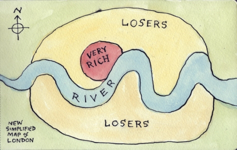
This map came from here. And so did the following comments:
- “I live in London and this map is fairly accurate. The Very Rich area would be Pimlico, maybe Notting Hill, Kensington and Chelsea, Westminster, the West End, Primrose Hill, maybe Hampstead. London has other wealthy areas but what differentiates these from those is that these areas have always been wealthy, rather than Johhny come lately areas that have been gentrified.”
- “General rules of thumb: in a city the wealthier neighborhoods tend to be upwind, upriver, and uphill. Occasionally extreme geographic constraints will override those rules. In the case of London, the Thames was horribly polluted and smelly in the first half of the 18th century (look up “The Great Stink”). My guess is that the “Very Rich” area would be the westernmost part of London in 1850, and that the “Losers” area west of there developed after the Thames was cleaned up. (I should line up some historical maps of London to the above map to see.)”
- “It just goes to show you. It takes a lot of losers to support a few rich folks.”
- “Have you seen the houses in Richmond or Hampstead? They don’t look like looser houses to me… There was actually an article in Time Out which mapped the London Boundary in relation to were the first Harvester eatery is located. So, were Harvester starts London stops. That is a clever way to show social divide within a city.”

Interesting map. Thank you for sharing. Blessings and love to you ♥